
A flash flood appears suddenly and quickly gains speed and strength. Sensors monitoring the river level in real time are an effective form of warning against threats. Still, they do not provide an opportunity to prepare for the upcoming flood much earlier. An integrated monitoring system that, in addition to sensors, considers the terrain model, its cover, soil data, weather radar data and finally accurate rainfall forecasts, may allow flood warnings to be issued well in advance.
How does the model predict rain?
Weather forecasting, including rainfall, is a complicated and complex process that requires hundreds of data and a supercomputer that will analyze this data and create a forecast through numerical simulation. A model is a computer program that calculates a forecast for a space divided into areas. In the case of the UM 1.5 km model (from which the data used in the FLOPRES project will come), the area is divided into a grid of squares with sides of 1.5 km.
The forecast can be calculated up to 78 hours ahead. Thanks to this, the forecast is more accurate than in the case of, for example, a global model with a 25 km x 25 km grid. The benefits of a grid with higher resolution are especially visible during summer convective rainfall, which often occurs in a small area and in a short time. We all know the cases when the rain occurs in a given district of the city and not even a drop of rain falls a bit further away. Thanks to the high-resolution grid, we can more accurately predict where there will be rain.
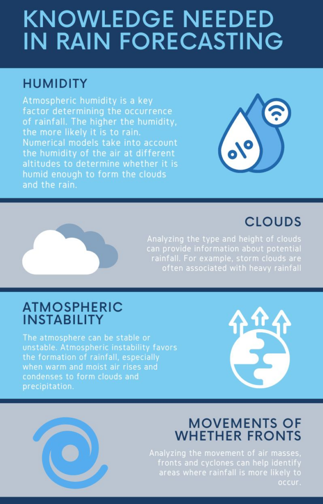
The infographic shows the factors taken into account by weather forecasters (meteorologists). The numerical model however works a little bit differently. It calculates the forecast of all meteorological parameters (like air temperature, pressure, humidity, and rainfall) at a specific time and place based on the solutions of a set of equations. However, due to the complexity of atmospheric processes such forecasts may be subject to a certain degree of uncertainty.
Verifiability of the weather forecast
Like any weather forecast, the results generated by the UM model are subject to verifiability assessment. Each meteorological parameter (such as temperature, wind, or precipitation) is assessed separately. As the reference points are used (among the others) the measurements are performed by the synoptic stations.

The verifiability of the model is also assessed taking into account how “old” the forecast is. Intuition suggests that the older weather forecast has worse quality. In many cases this is indeed the case, but not always. There are situations in which the latest forecast is more wrong than the previous one. Therefore, meteorologists often use a set of forecasts to assess how much a given forecast is influenced by even small changes.
Different models have different spatial resolutions, which translates later into forecasting. To illustrate this, the infographic shows the precipitation field forecasted by three different models: the GFS model with a 0.25° (~27km) grid resolution, and the UM model with a 4km and 1.5km grid resolution. More and more details can be found when the distance between grid points is lower. It is like zooming in.
While the model’s ability to accurately reproduce rainfall is important, it does not guarantee complete prediction success. Each model requires careful verification of its results. The UM model is characterized by good verifiability. It is also a valued tool for forecasters responsible for national
meteorological protection.
Meteo.pl as a partner of the Flopres project
One of the partners of the FLOPRES project is Meteo. Thanks to 30 years of experience in modeling meteorological conditions in Central Europe and cooperation with the British meteorological service Met Office, Meteo.pl has become one of the most recognizable and professional meteorological services not only in Poland but also in the surrounding countries.
The origins of Meteo.pl date back to 1994, when several attempts were made to create a Numerical Weather Forecast in Poland. Just a few years later, in 1997, the numerical model (UM) correctly predicted in advance heavy rainfall, which contributed to the “flood of the millennium” in Lower Silesia in Poland and in some neighboring countries: Slovakia, the Czech Republic, Germany, and Austria. A more recent example of accurate forecasting of dangerous rainfall was in February 2024. Then the UM 1.5 km model accurately predicted intense rainfall which caused the overflow of the Prądnik River (the tributaries of which are in the pilot area of the FLOPRES project) and local flooding.

In the case of flash floods, an accurate forecast is crucial because it allows for quick response and minimization of damage and risk to people and property. Combined with water monitoring and other elements of the system, weather forecasts are an important element of an effective strategy to counteract flash floods.