
In recent decades, significant changes in atmospheric dynamics have been observed, resulting in an
increased frequency of extreme weather events, such as flash floods. The rising temperatures on Earth
have a key impact on rainfall intensity, altering established weather patterns and heightening the risk of
natural disasters.
What are flash floods?
Flash floods are sudden and intense inundations that occur following short but very heavy rainfall. They can develop within hours of a downpour, significantly complicating preparation and evacuation efforts.
Areas with mountainous terrain and highly urbanized zones, where impervious surfaces like asphalt and concrete accelerate water runoff, are particularly vulnerable.
The link between climate change and flooding
Climate change impacts the atmosphere in ways that foster intense rainfall and rapid flooding:
- Increased atmospheric moisture: A warming climate enhances the atmosphere’s ability to hold moisture. According to physical laws (Clausius-Clapeyron equation), each 1°C increase in temperature allows the air to retain about 7% more water vapor. Consequently, storms can produce more rainfall in a shorter period. In the case of the floods in Poland and Slovakia in September 2024, this rate reached even 10% per 1°C rise.
- Changes in atmospheric circulation patterns: Global warming alters jet streams, leading to greater stagnation of storm systems. When a storm system “stalls” over an area, prolonged rainfall can result in localized flooding. This phenomenon is linked to “blocking events,” where high pressure systems or meandering jet streams trap storm systems in one region.
- Greater storm energy: Higher surface temperatures of the Earth and oceans increase the energy available to storm systems, making them more intense.
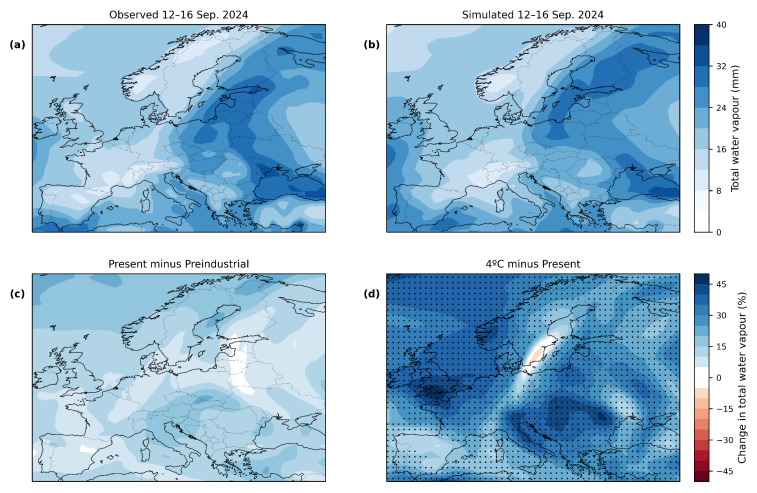
case of the same extreme phenomenon in pre-industrial times and in a world warmer by 4 degrees Celsius
Catastrophic floods in Poland and Slovakia
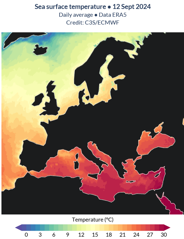
Data from the ClimaMeter project (funded by the European Union and the French National Center for Scientific Research) reveal that the Genoa low “Boris” in September 2024, which caused severe flooding in Poland and Slovakia, was the result of a deep atmospheric depression (-10 hPa) in Eastern Europe. The contrast between cold air and the warmer-than-average waters of the Mediterranean Sea contributed to extreme rainfall. Mediterranean Sea temperatures reached up to 32°C, amplifying atmospheric moisture. Warm water evaporates faster, injecting more water vapor into the atmosphere. When this moisture-rich air mass collided with cooler air from the North Atlantic, it fueled massive rainfall events.
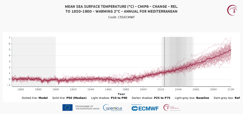
It also illustrates the projected temperature rise by 2100 under a 2°C global warming scenario.
Additionally, the low-pressure system was blocked over southern Poland due to expansive high-pressure systems in the west and northeast of the continent. This caused rainfall to concentrate in one area rather than being evenly distributed. While the number of similar Vb depressions (a category associated with the (1997 and 2024 floods) has not significantly changed since the 1950s, their intensity has increased. Four-day heavy rainfall events have become roughly twice as likely and 10% more intense compared to the pre-industrial era.
Locally, the inability of soils to absorb water, due to prior droughts and urbanization, exacerbated the flooding. Impermeable surfaces such as asphalt and concrete further intensified the effects of rainfall.
Shifting timing of extreme rainfall
Scientists have noted a shift in the timing of severe floods in recent decades. The “Millennium Flood” in 1997 occurred in July, the flood in 2002 in August, and in September 2024 another catastrophic flood took place. This indicates a trend of extreme rainfall occurring in months that historically were not typical for such events in Central Europe. While extreme rainfall previously concentrated in the summer months, climate changes, such as Mediterranean warming and jet stream shifts, may be pushing the season for extreme rainfall into later months, increasing the risk of flooding during periods that were once relatively dry.
How can we prepare?
Reducing the risk of flash floods requires both global action to mitigate climate change and local adaptation strategies. Key steps include:
- Early warning systems: Advancing technologies, such as IoT sensors and hydrological models, can help predict floods and minimize their impacts.
- Sustainable urban planning: Implementing solutions like green roofs and retention basins enhances stormwater management.
- Public education: Raising awareness about flood risks and preventive measures can save lives and reduce damage.
In summary, flash floods are becoming an increasingly serious problem in Europe and globally. Their growing frequency and intensity are among the effects of climate change, which demand both immediate adaptive measures and long-term strategies to reduce greenhouse gas emissions. Collaboration at local and international levels is key to building resilience against these dynamic and destructive phenomena.
The Flopres project offers a comprehensive solution supporting flood modeling, forecasting, early warning systems, and the integration and analysis of interdisciplinary data. It is designed for institutions managing water and crisis situations at various levels and for individuals exposed to the impacts of extreme climate events. Additionally, the project aims to raise public awareness and stakeholder engagement in adopting nature-based solutions as an effective method for climate adaptation, promoting collaboration between local communities and authorities to achieve common goals.